01
Collect Existing Conditions
Use field survey data and available project information to document the existing terrain, roads, structures, and site features.
Loading portfolio
Civil Site Design
Supporting residential grading plans through survey-data processing, surface creation, contour development, drainage review, and construction-plan drafting.
Role
Survey/Civil Engineering Intern
Project Type
Residential Site Grading
Primary Software
AutoCAD and Carlson Survey
Primary Focus
Surfaces, contours, and drainage
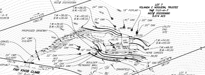
Existing Conditions
Survey data, site features, elevations, and terrain information
Surface Work
Existing-ground surfaces, breaklines, and contour development
Drafting Support
Proposed contours, slopes, elevations, labels, and plan cleanup
Project Context
Residential subdivision and land-development grading
Overview
Grading design connects the existing terrain with the proposed roads, lots, drainage features, and finished construction elevations. Each contour represents part of a larger surface that must function continuously across the development.
During my internship, I supported this process by working with survey data, developing and reviewing surfaces, drafting contour information, and preparing grading-related plan documentation. The work required careful attention to both technical accuracy and drawing clarity.
Grading Workflow
01
Use field survey data and available project information to document the existing terrain, roads, structures, and site features.
02
Organize field observations and develop usable linework and elevation information for the existing site.
03
Build a digital representation of the existing terrain using surveyed elevations, breaklines, and site features.
04
Support proposed contours, finished elevations, slopes, drainage paths, and grading transitions around roads and lots.
05
Translate the grading information into a readable construction plan with labels, contours, details, and supporting notes.
Plan Development
The grading plan combines existing and proposed contours, road geometry, residential lots, drainage features, slopes, elevation labels, notes, and construction details into a coordinated document.
Surface Modeling
A digital surface converts surveyed elevations and breaklines into a model of the site terrain. Contours then provide a readable plan-view representation of that surface.
Surface quality depended on organized survey information, correct feature interpretation, and careful review of contour behavior around roads, slopes, drainage areas, and proposed improvements.
Drainage and Slopes
Proposed grading needed to establish positive drainage away from buildings and maintain continuous flow toward the intended drainage features.
Roads, lots, embankments, drainage areas, and existing terrain could not be considered independently. Each transition influenced the performance and constructability of the surrounding site.
Drawing Interpretation
Understanding the sheet required following the relationship between contours, spot elevations, roads, lots, drainage features, slopes, and existing site conditions rather than reading each item independently.
01
Show the shape, elevation changes, and direction of the proposed terrain.
02
Provide precise elevations at critical locations such as roads, structures, and drainage points.
03
Define transitions between higher and lower areas while supporting drainage and constructability.
04
Collect, direct, or manage runoff as it moves through the development.
Engineering Challenges
A grading plan is successful only when the modeled surface functions technically and can also be interpreted clearly by the people using the construction documents.
01
Proposed grading needed to direct water away from buildings and roadways while maintaining a continuous drainage path across the site.
02
Changes between roads, lots, slopes, and drainage features had to be represented smoothly without creating unrealistic or abrupt contour patterns.
03
The finished sheet included contours, elevations, road geometry, grading labels, drainage information, and site features that needed a clear visual hierarchy.
04
The quality of the grading plan depended on correctly processing the original survey information and preserving important terrain features.
What I Learned
This work strengthened my understanding of how survey data, terrain modeling, roads, residential lots, slopes, and drainage systems come together within a civil site plan.
It also reinforced the importance of reviewing grading as a continuous system. An adjustment in one area can change drainage behavior, contour transitions, elevations, and constructability elsewhere on the site.